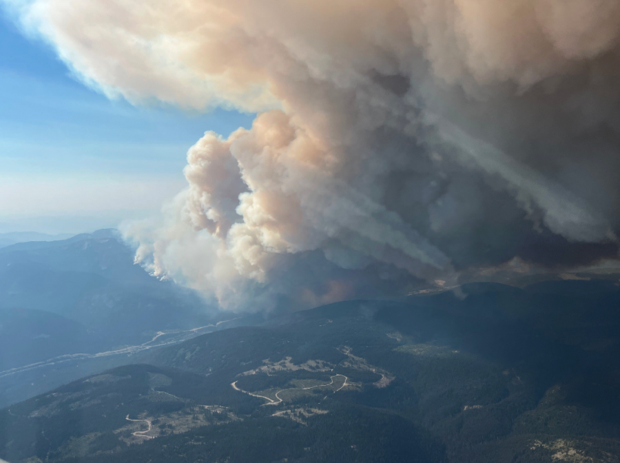
(UPDATE: Sept. 4 @ noon) – The BC Wildfire Service (BCWS) has provided some context about what caused the Mine Creek fire to explode and jump the Coquihalla on Wednesday.
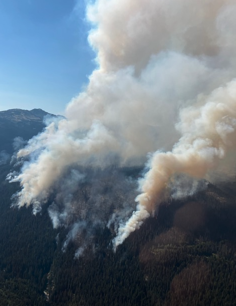
According to an update provided by the agency, record high temperatures and winds beyond what was forecast resulted in rank five fire behaviour.
That is the second highest rating of fire behaviour and means there is an active crown with moderate to long-range spotting and independent spot fire growth.
As of Thursday morning, the 1,900-hectare fire is displaying rank two and three behaviour meaning it is still a moderately vigorous surface fire.
.png)
However, temperatures are forecast to increase this afternoon which will cause fire behaviour to ramp up and for additional growth to be recorded.
Wildfire crews, aerial resources and structure protection units are now responding to the blaze.
“Accessing this fire has been challenging due to the terrain and multiple bridge washouts from previous flooding, priorities are securing Highway 5 and the protection of infrastructure in the area,” the BCWS said.
Crews will be working along the east side of the fire to establish access where it is safe to do so.
The Coquihalla remains closed and the next update will not be released until 2:30 pm.
(UPDATE: Sept. 4 @ 7:45 am) - The BC Wildfire Service says the Mine Creek wildfire is now 1,900 hectares after exploding in size on Wednesday.
That's around four and a half times bigger than the previous size estimate provided by the Wildfire Service early Wednesday afternoon.
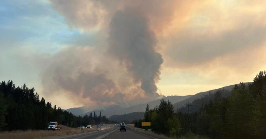
The Coquihalla remains closed in both directions between Merritt and Hope. Evacuation orders and alerts are in place. In formation on the highway and evacuations can be found in the update below.
(UPDATE: Sept. 4 @ 5:03 am) – The Coquihalla remains closed in both directions between Merritt and Hope this morning as the Mine Creek wildfire continues to burn out of control.
DriveBC said it will provide its next update at 10 am today.
Drivers have been advised to use Hwy 1 or Hwy 3 instead.
Meanwhile, one evacuation order and two evacuation alerts have been issued for properties near the highway.
The evacuation order was issued by the Thompson-Nicola Regional District last night, alongside an evacuation alert by the same district and another issued by the Fraser Valley Regional District.
The order affects only one property, but the alerts cover the following:
- Brookmere
- All properties on Murray Lake and Maka-Murray FSR
- All properties along the Coquihalla Hwy south of the Larson Hill exit (Exit 250) to the southern TNRD border at the Britton Creek Rest Area
- The Coquihalla Lakes area, including the Coquihalla Summit Recreation Area north to the boundary of the Thompson-Nicola Regional District
Anyone in the affected areas has been told to be ready to leave at short notice.
BC Wildfire Service said in its most recent update that the fire is showing Rank 5 behaviour, meaning "extremely vigorous surface fire or active crown fire."
The agency estimates the fire is still 483 hectares in size.
"Crews will continue to action the fire overnight with the support of a helicopter," BCWS said in a statement last night.
(UPDATE: Sept. 3 @ 4:10 pm) – The Coquihalla highway has closed between Hope and Merritt Wednesday afternoon.
The highway was officially closed at 3:55 pm.
A detour is in effect via Highway 1 or Highway 3 and delays should be expected.
Motorists are reminded that no commercial vehicles are allowed on Highway 8.
Several people have taken to the Coquihalla Road Reports (And Area) Facebook group to share pictures of the Mine Creek fire.
A few people travelling the Coquihalla have reported that the fire is about one kilometre south of Juliette Creek and has jumped the highway. However, that has not been confirmed by officials.
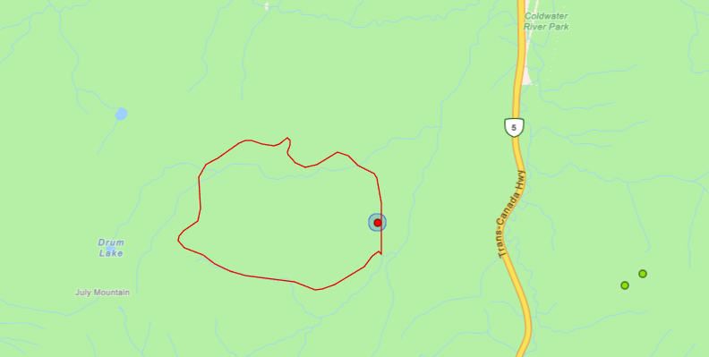
The most recent BC Wildfire Service (BCWS) update pegs the Mine Creek fire at 483 hectares, up from the 420 hectare estimate provided earlier in the day.
That number was provided early this afternoon and is likely to grow next time the BCWS is able to provide updated mapping of the blaze.
To date, there has been no response to the fire due to the steep and remote location of the fire.
The BCWS said they had helicopters monitoring the fire but ground crews were unable to access the site.
.png)
(1).png)
(UPDATE: Sept. 3 @ 12:02 pm) – The BC Wildfire Service (BCWS) has said it is allowing the Mine Creek wildfire to burn to maximize ecological benefits.
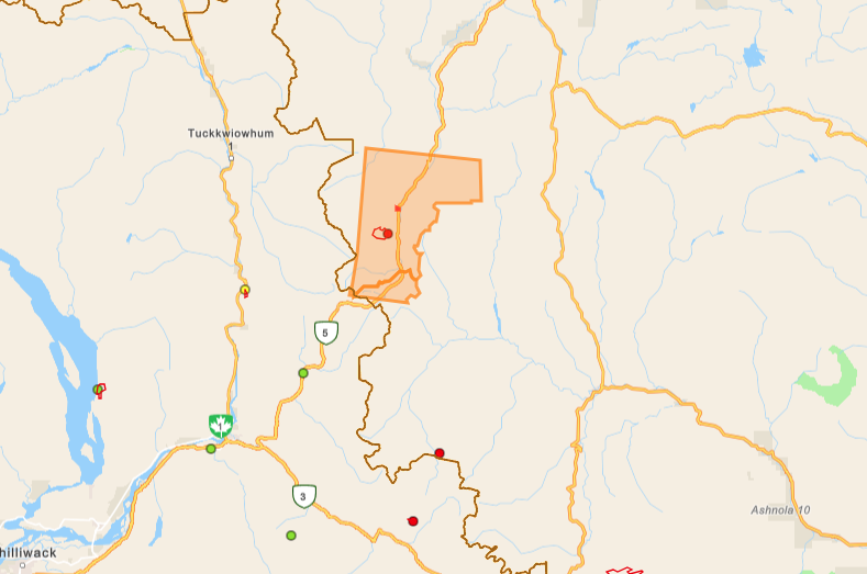
The fire, which is burning to the west of the Coquihalla, is estimated at 420 hectares.
The lightning-caused fire is burning in high terrain surrounded by steep and rocky slopes.
There is also no road access to the fire.
As a result, there are no resources actively fighting the fire due to the inability to safely deploy crews.
“During a modified response, a wildfire is managed using a combination of techniques with the goal to minimize damage while maximizing ecological benefits from the fire,” the BCWS said.
“Should the fire move into actionable terrain, or pose a threat to infrastructure, BC Wildfire’s response will adapt accordingly.”
The fire is being monitored by multiple helicopter flights daily and night vision helicopters overnight to assess its growth and movement.
A map of the fire shows it is burning west away from the Coquihalla.
On a side note, two small lightning-caused fires discovered on the east side of the highway are now both under control.
(UPDATE: Sept. 3 @ 6:23 am) – The fire has now grown to 420 hectares, according to the latest update from the BC Wildfire Service.
It remains out of control.
Despite being "highly visible" from the Coquihalla, BC Wildfire Service said, "the fire is currently burning upslope and into a previously burned area, decreasing fire behavior [sic]."
The agency added: "It is not threatening any structures, roads, or utilities at this time."
Thumbnail photo credit: Jennifer Danelisky
(UPDATE: Sept. 2 @ 2:20 pm) – The BC Wildfire Service has provided an update to the Mine Creek wildfire, which is burning off the Coquihalla (Hwy 5).
As of Tuesday afternoon, the fire is estimated at 275 hectares.
Due to its remote location, there are no resources assigned to the fire at this time.
“While this incident is highly visible from the Coquihalla Highway (Highway 5), the fire is currently burning upslope and it is not threatening any structures, roads, or utilities at this time,” The BCWS said.
The highway is not being impacted by the fire.
(Original story: Sept. 2 @ 9:32 am) – The BC Wildfire Service (BCWS) is responding to a “highly vigorous” wildfire that started off the Coquihalla on Monday.
The Mine Creek fire (K61891) is burning out of control and is estimated at 105 hectares, according to an update provided by the BCWS Monday evening.
.png)
The fire, which is burning 44 kilometres northeast of Hope, was displaying rank four behaviour.
That means it was a highly vigorous surface fire with torching or passive crown fire.
At this time, the BCWS believes the fire was caused by lightning.
“While this incident is highly visible from the Coquihalla Highway (Highway 5), the fire is currently burning upslope and it is not threatening any structures, roads, or utilities at this time,” the BCWS said.
.png)
As of Tuesday morning, there are no road closures in place.
New information could be shared by the BCWS today and this story will be updated once those details are made available.


