Canadians are headed to the polls in a little over a month and voters should be aware of new ridings in British Columbia.
Prime Minister Mark Carney called for a federal election on Sunday and it will be held on April 28.
A new federal electoral map for BC was adopted back in July 2023, however, there was no election that year so some residents may be unaware of the changes.
Maps were changed across the country to keep the populations in electoral districts as even as possible while also taking into account the communities of interest or identity, said the Federal Electoral Boundaries Commission for BC.
.png)
Before the changes, the Okanagan was split between four ridings that included North Okanagan–Shuswap, Kelowna–Lake Country, Central Okanagan–Similkameen–Nicola and South Okanagan–West Kootenay.
There are still four ridings in the Okanagan but their boundaries have drastically changed.
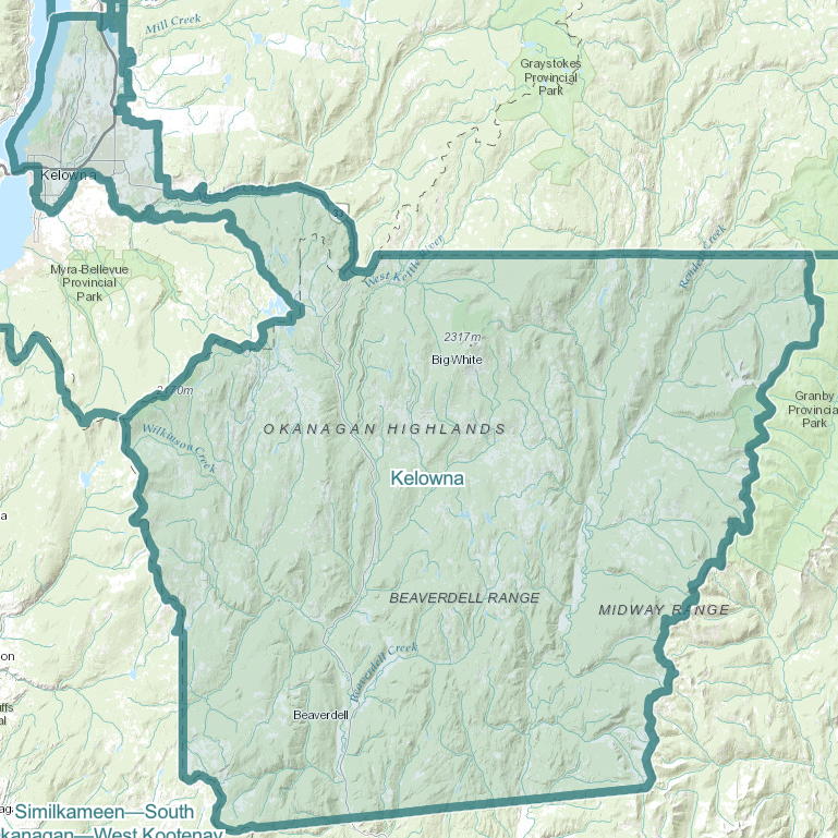
One of the most notable changes is that the majority of Kelowna is now its own riding and includes everything north of Mission Creek north towards Ellison Lake, Big White, Carmi and south of Beaverdell.
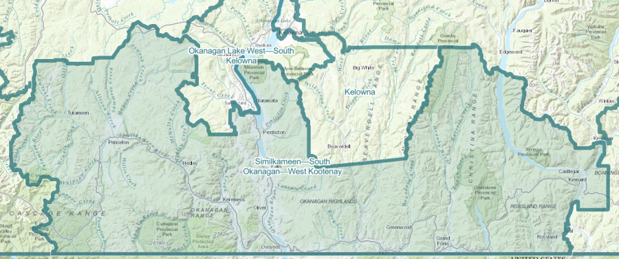
The new Okanagan Lake West–South Okanagan includes Wilson Landing, Traders Cove, West Kelowna, the rest of the City of Kelowna that is south of Mission Creek, Peachland and Summerland.
The new Similkameen–South Okanagan–West Kootenay riding is a sort of hodge podge of the old Central Okanagan–Similkameen–Nicola and South Okanagan–West Kootenay.
The boundaries stretch from EC Manning Park in the west to Castlegar in the east. It includes Princeton, Hedley, Keremeos, Oliver, Osoyoos, Penticton, Naramata, Grand Forks, Rossland and Castlegar.
Meanwhile, in the north, the North Okanagan–Shuswap riding is no more and has been replaced with the Vernon–Lake Country–Monashee riding.
This riding includes Kelowna’s Ellison area, Winfield, Lake Country, Oyama, Vernon, everything north of Fintry, Coldstream and stretches as far east as Slocan in the Kootenays.
The boundary between that riding and the new Kamloops–Shuswap–Central Rockies map starts just south of Armstrong.
The Kamloops–Shuswap–Central Rockies map replaces a portion of the old Kamloops–Thompson–Cariboo riding.
It includes Armstrong, Enderby, the entire Shuswap, eastern parts of Kamloops, Revelstoke, Golden and Field.
.png) Also focusing on the Kamloops area, the new Kamloops–Thompson–Nicola riding includes the western parts of Kamloops, Merritt and rural areas to the east including Douglas Lake.
Also focusing on the Kamloops area, the new Kamloops–Thompson–Nicola riding includes the western parts of Kamloops, Merritt and rural areas to the east including Douglas Lake.
This map also includes Logan Lake, Lytton, Lillooet, Cache Creek, Ashcroft, Clinton, Barriere, Clearwater and Chase.
You can click here to view a map that shows the old ridings compared to the new ones.


